Showing posts with label Montevallo. Show all posts

Thursday, August 6, 2026

Chloroform in Montevallo in 1848

General anesthesia using gases for surgery is one of America's great nineteenth century medical achievements. In early 1845 dentist Horace Wells used nitrous oxide to painlessly extract a tooth. In October 1846 dentist William T.G. Morton successfully demonstrated ether anesthesia in Boston during an operation by John Collins Warren. The Morton/Warren event soon made it's way around the world. The Wood Library-Museum of Anesthesiology outside Chicago maintains an extensive timeline that covers all sorts of anesthesia developments worldwide from ancient times until today. 

After a long search for an anesthetic without ether's smell and other side effects and lasting longer than nitrous oxide, Dr. James Young Simpson and colleagues in Edinburgh, Scotland, discovered chloroform in November, 1847. The following May, Dr. Andrews of Montevallo reported that he had used chloroform to amputate "a negro boy's leg, "immediately below the knee", while under the influence of this powerful agent. "[H]e declared he did not feel or know anything of the operation."

I have mentioned this event in Shelby County on a previous blog post about general anesthesia in Alabama and in an article I published in 1986. I found the Montevallo demonstration covered in a Montgomery newspaper item reprinted from the Tuscaloosa Observer, and I wanted to discuss it more here.

Since the "negro boy" patient is not named, I only had a "Dr. Andrews" in Montevallo to research. Luckily, I think I've tracked him down.

David Andrews is listed in the 1850 U.S. Census and living in Shelby County. He was a physician, 30 years old, and born in North Carolina. He was married to Harriet F. Embrey [b. 9 July 1823] and they had 5 children at that time, 3 daughters and 2 sons. She died on July 31, 1855, age 32 and is buried in the Montevallo Cemetery. According to an inventory of that cemetery, an infant son is buried there also. 

Also according to the 1850 U.S. Census--Slave Schedules Andrews was a slave owner. He had 5 slaves at that time, 2 adult males, a boy of 7 and 2 adult females. Thus Andrews was probably also a farmer; many physicians in the 19th century, especially in rural areas, needed additional income beyond what their practices could provide.

I have been unable to locate any more information on David Andrews, despite searches of census and cemetery records and American physician directories covering the period. Perhaps he left Alabama after his wife died. 


FURTHER READING

Wright AJ. Early Use of General Anesthesia in Alabama, 1847-1853. Ala J Med Sci 1986 July; 23(3):333-335


Montgomery Tri-Weekly and Flag Advertiser 30 May 1848

Source: Gale Historical Collections. 19th Century U.S. Newspapers database


The current Montgomery Advertiser was published under this title from January 1, 1847 until December 7, 1848.

Source: Encyclopedia of Alabama 


Tuesday, September 19, 2017

Montevallo is Missing! [My 350th blog post!]

Well, sort of. And only on a map. Sort of....let's investigate.

On September 9th, the city of Montevallo had a festival to celebrate it's bicentennial. Like Pelham, once known as Shelbyville and Shelby County's original seat of government, Montevallo predates Alabama statehood in 1819. 

The first white settler in the county, Jess Wilson, arrived in 1814 and others followed as the Indian threat diminshed. The area became "Wilson's Hill" by 1822 and Montevallo in 1826 according to Clark Hultquist and Carey Heatherly's Montevallo [Arcadia Images of America series, 2011, p. 11]. You can read some more early history here. Montevallo was incorporated by the state legislature in 1848 when almost 1000 people lived there. 

Columbia in the southern part of the county became the seat in 1826 and a post office was established. The town became Columbiana in 1832 and incorporated in 1837.

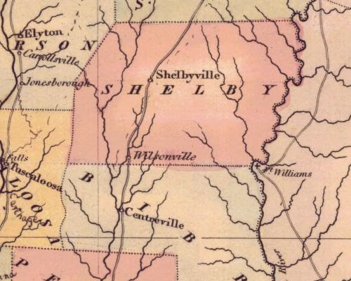
I was perusing some old Alabama maps recently and noticed something interesting related to this early history. Excerpts are below; all map portions are taken from the state maps at the University of Alabama's Historical Map Archive. You'll note some mysteries as you look at these maps and read my comments. Montevallo appears on a map as early as 1823, then an 1824 map lists "Wilson Hill" but no "Montevallo". 

These maps from the 1820's and 1830's vary in the towns shown. Making maps in those days was hardly a standardized business. Did mapmakers in Philadelphia or Baltimore actually visit these places or copy from previous maps or what?

Feel free to leave insights in the comments section!


On John Melish's 1818 map of Alabama, we see Shelby County in its earliest form. The county was created by the legislature of the Alabama Territory in February 1818. The only named locations in Shelby at this time were Fort Strother and Fort Villanos, Camp Wills and Camp Bradley and Littafuchee. All but Fort Villanos would become part of St. Clair County when it was created in November.

Fort Strother was constructed during the Creek War by several thousand of Andrew Jackson's Tennessee Militia  just before the Battle of Talladega on November 8, 1813. Presumably the other fort and camps were also a part of that war. Littafuchee was an Upper Creek town; the name means "making of arrows." In October 1813 some of the Militia captured the town 


Portion of Fielding Lucas' 1822 map of Alabama that shows two towns in Shelby County at that time. A post office was established at the current Wilsonville in the same year; the town wasn't incorporated until 1897. But this map shows a weirdly shaped Shelby County; is this Wilsonville supposed to be Wilson's Hill? Montevallo is in southern Shelby County, after all, and today's Wilsonville is in the eastern part near the Coosa River.


On this section of Henry S. Tanner's 1823 state map, we find Shelbyville and Montevallo as well as Kelley's Village in the northeastern corner of the county.


Anthony Finley's 1824 state map lists only Shelbyville and Wilson Hill. What happened to "Montevallo"?


Henry S. Tanner's 1825 map again lists not only Shelbyville and Montevallo, but  also Kelley's Village. That third place is a mystery; it doesn't appear in Virginia Foscue's Place Names in Alabama [University of Alabama Press, 1989]. However, there are a Kelley Mountain and Kelley Creek in Shelby County.


Taken from David Burr's 1836 map of Alabama. Notice there are still only two towns noted in Shelby County, Shelbyville and now Montevallo. Poor Columbiana, the country seat, is getting no recognition here.