Wednesday, March 29, 2017

Quick Visits to Confederate Memorial Park & Horseshoe Bend


In July 2012 my brother Richard and I took the first of our summer trips together visiting sites mostly related to either Alabama history or family history in the state. On this trip we took in not only the two places discussed in this post, but sites in other cities such as Sylacauga, Alexander City, Gadsden, Rainbow City and Hokes Bluff. Future blog posts on those place are coming.

I'm finally starting to do something on this blog with all the photos I took, so here's where we begin. These two places are related to a pair of defining periods in national and Alabama history--the Creek War of 1813-1814 and the Civil War.

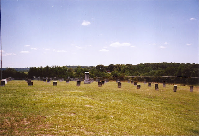
We stopped first at Confederate Memorial Park in Chilton County. This park and museum is located on the site of the Confederate Soldiers' Home, which the state operated from 1902 until 1939 for aging veterans, their wives and widows. The park was created in 1964; in 1971 the Alabama Historical Commission took over operations. The Encyclopedia of Alabama has a history of the facility available here.

There are several things to see in the park. The modern museum has numerous artifacts related to the average Confederate soldier and the postwar years. Almost 300 veterans and several wives and widows are buried in the two cemeteries. The property also has a nature trail through an Alabama Treasure Forest. The Mountain Creek Post Office built in 1900 and the Marbury Methodist Church built in 1883 have been moved to the site. 

Once we had finished at the Park, we headed off to Tallapoosa County and the National Military Park at the Horseshoe Bend of the Tallapoosa River. First stop was the Visitor Center and its exhibits. Then we headed to the battle site itself.

On March 27, 1814, General Andrew Jackson led a force of Tennessee militia, regular US soldiers, and his Cherokee and Lower Creek Native American allies into battle against Chief Menawa and his Upper Creek or Red Stick warriors. The conflict had begun the previous year as a civil war among the Creeks, with some siding with Americans in the War of 1812 and others hostile to the United States. 

Menawa, some 1000 warrior and 350 women and children had settled in a temporary, fortified village named Tohopeka in December 1813. Jackson arrived with some 3300 men. You can read the details of the Red Sticks' devastating loss here. The final result was the Treat of Fort Jackson in which the Creeks turned over more than 20 million acres of their lands to the United States. After Jackson became president in 1828, he signed the Indian Removal Act after which Creeks and Cherokees were forced to move to Indian Territory during the 1830's. The area is now Oklahoma; I've written a blog post on some of the Creek names that followed the people. 

I've made some further comments below. All photos are mine unless otherwise noted.


Here's Richard in front of that Mountain Creek post office. Several photos below show the cemetery close to the museum.


Memorial Hall was built in 1902 and included the commandant's office, a library, a parlor, and a conference room. The upper floor was used as an auditorium. Fire destroyed the building in 1924.


This photo shows the museum and a flag display. 


These three photos show the site of the Battle of Horseshoe Bend as it looks today. On the other side of the trees the Tallapoosa River winds around the bend. All was quiet that day, a sharp contrast to the March day 200 years ago when so many Creeks and whites died here. Jackson's force lost 49 men and more than 150 were wounded. Some 550 Red Sticks died on this field; an estimated 300 more were shot in the river. 


We were standing on the "high ground" near the location of the breastworks noted on the map below when I took these photos.


Source is here.


Another map of the Bend and the battle.

Source: Encyclopedia of Alabama


This same guy reappeared at Horseshoe Bend.


Wednesday, March 22, 2017

Snowfall on Cloverdale Drive in 1958

Back in January I posted an item on a family trip to the beach in 1956. This time it's winter in 1958. According to the National Weather Service, eight inches of snow fell in Huntsville, Alabama, in February 1958. I think I have the evidence. Let's investigate.


A Weather Service chart here tells us that this snowfall was the most Huntsville has ever received in February. The only deeper ones were December 1963 (a whopping 21.4 inches!) and January 1988 (9.6 inches). 


We begin our story with the cover of the photo album provided by H & H Walgreen Agency Drugs, an artifact from a dim past itself.


Here I am with mom and little brother Richard. I seem to be trying to take possession of the snowman. We are really bundled up!


Putting on what is supposed to be the head at this point. This photo shows the house on Cloverdale Drive in northwest Huntsville. I was born in Gadsden in 1952, and we moved to Huntsville a couple of years later. This house is the first one I remember from childhood. We lived in Redstone Park after first moving to Huntsville.  


Now we must have wandered over to the corner of the house. Brother Richard seems to have gotten tired of walking in that snow.


Lots of snow around this "pretty blue Ford" as mom remembers it. The car was my parents' first one, bought second hand. That's license number 47-6152, by the way. Remember when Alabama vehicle tags began with the two digit number designating the county? So "47" was Madison County. 

Too bad that system was dropped a few years ago. We used to entertain ourselves on trips around the state by seeing how many different counties we could spot.


Another shot of the front of the house and the snowman, with that Ford appearing in this one.


Richard was on his own at least once in this blizzard. This snow may have been the first significant one he had seen. 
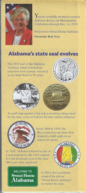

And a final picture features just the snow, a corner of the house with garbage cans, a fence and a telephone pole. Another house can be seen on the right and snow covered roofs across the fence. A nice composition by dad, our photographer. Too bad we didn't get him in any photos of this event.


Friday, March 17, 2017

Some Alabama Highway Map Covers (2)

In part one of this blog post, I discussed some of the "official" highway maps of Alabama that I've collected over the years as well as a few published by the Rand McNally company. I also included a brief look at the history of road and highway maps in general. Here's another selection of mostly official ones; some comments below.

I should probably note some covers on these state maps that I'd like to see in the future. How about one featuring a collage of the state's famous writers--Harper Lee, Rick Bragg, Fannie Flagg, Robert McCammon, and so many more? Or a collage of the state's film and TV stars--Jim Nabors, Kate Jackson, Courtney Cox, Henry Walthall, Cathy O'Donnell, and that young whippersnapper from Cullman whose name escapes me? Oh, right, Channing Tatum. Or maybe Helen Keller, perhaps the single most famous individual from Alabama?

Ah, well, I guess those sorts of covers might not attract the tourists like yet another one featuring the beach!


Here we have two typical map covers--an historic site and a site of natural beauty.


One more beach cover, and another historic site. Looking over all these maps I've collected, I'm pleased to see how many have featured historic places.


At some point the back cover of these maps transitioned from photos and statements from the governor and the state highway director to a photo of the governor and his wife along with a statement. Someone seems to be missing from that map on the right, however.


OK, ok, another beach cover. But this one's pretty cute, and those beaches do bring in a lot of dollars.


Wait--they have a Shakespeare festival in Alabama? I think this may be the only one I've collected that features the performing arts. Perhaps the Alabama Ballet is due for a cover? The Alabama Symphony Orchestra

I'm really surprised none of the country music acts or American idol winners from Alabama have appeared on a map cover. 


This one is the second map cover to feature the Space and Rocket Center in Huntsville. Our kids Amos and Becca both did a week at Space Camp and enjoyed it. 


Beach map covers always show the blue water and white sands--where are the jellyfish? Sharks? Sand burrs? Or maybe just a dune or two?


Wait--they have museums in Alabama? 

This one is certainly worth a visit, as we've done periodically over the years. Son Amos and daughter Becca always enjoyed a tour, especially when it started with one of those wonderful Sunday jazz brunches! 

Oh, and the Alabama Museums Association has a long list of members. Maybe another one will be featured on an official highway map in our lifetime.


And finally a Rand McNally map and one of those free gas station maps from back in the day. Dad dated this one for us.


UPDATE 1 February 2019

I wanted to add the newer highway maps for 2017-18 and also a specialized map from 2001.


Update 20 August 2019: And here's the 2019-2020 official state highway map:


This one has the same "icons" featured on the back cover.


Tuesday, March 14, 2017

A Visit to Aldridge Gardens in Hoover

Recently Dianne & I visited Aldridge Gardens in Hoover, one of those places we've been meaning to visit for a long time. We spent a very pleasant hour wandering the trail around the park's lake and seeing the sights. 

The facility's web site offers some information about the Gardens' history and amenities: 

"Since Aldridge Gardens opened in 2002, the 30-acre former property of well-known horticulturist Eddie Aldridge and his wife Kay has become a popular attraction in the greater Birmingham area. The young garden showcases hydrangeas, including the Snowflake Hydrangea, which was patented by Mr. Aldridge and is now the official flower of the City of Hoover.

Other features include an event venue and gallery in the couple's former home, an outdoor pavilion, a six-acre lake and a half-mile walking trail. The Gardens also host plant sales, art exhibits and shows, classes and seminars, bird walks, fishing days, concerts and more."

Admission to the Gardens is free. The trail is an easy walk and there are plenty of benches along the way. Also to be seen are several whimsical sculptures by Frank Fleming, which for some odd reason I did not photograph. Maybe next time. 

Dianne mentioned that ironically the backdrop to all this natural beauty was the sound of traffic on the nearby Interstate highway.

Photos and a few comments below. 


The Gardens have lots of natural beauty that will only increase in coming weeks.


Here's an interesting sculpture you come across on the back side of the lake. Orr Park in Montevallo has more than 30 of these chain saw sculptures created by Tim Tingle since 1993. He only carves in dead or dying trees, and I suppose something similar was done to this cypress. I don't know if it's by Tim Tingle, though. 


The park has a significant display honoring veterans.


Several mallard ducks entertained us while we were there. We'll have to bring food next time.