Showing posts with label highway. Show all posts

Friday, February 2, 2024

Alabama Official Highway Maps 2023-2024

I've done a number of posts on this blog about various maps, usually related to Alabama, Shelby County or Pelham. One of these days I hope to do a piece linking all those items together. In the meantime, here's another one...

This post is the fourth featuring those "Official Highway Maps" of the state you can get for free from the state travel website or pick up at welcome centers or rest stops. I love these maps with their colorful covers; and when you open them up, you have a huge detailed map of the state. 

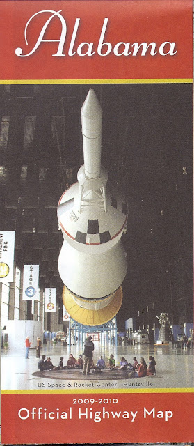
In the first entry in this series I covered maps from 1976 until 2009-10. Images included the Space and Rocket Center, Barber Motorsports Museum, a statue in Tuskegee, bike riders, the state coat of arms, a beach or two and much more. Images in the second post covered the Gorgas House in Tuscaloosa, Sturdivant Hall in Selma, the Alabama Shakespeare Festival, Birmingham Museum of Art, a different Space and Rocket Center photo, Birmingham Museum of Art, and others, including beaches. The dates in that post ranged from 2004 to 2021-22. Just for fun I also included a 1974 state map from Texaco and a railroad map issued by the state.

In the early days the back cover might include examples of road signs or in at least one case just "HELP" which could be put on your dashboard. However, most back covers feature the governor at the time and that practice continues today. The third post focused on a 1973 map I came across, with George Wallace on the back. I'm not sure when the state started creating these particular kinds of maps.

So now we come to the latest highway map covers, and here they are....


Thursday, May 23, 2019

W.S. Newell HIghway

Recently we made a trip to see our daughter Becca Leon and grandson Ezra who live near Jacksonville, Florida. On the way back to Pelham we ended up stuck for two and a half hours in a massive traffic jam on I-65 just north of Prattville. Unfortunately, the problem was caused by a wreck involving two commercial vehicles and the death of one of the drivers. The backup lasted for more than ten hours. 

Traffic was shuttled off the interstate onto US 31 at the Pine Level exit; the wreck was several miles north toward the Verbena exit. As we crawled toward that exit, I noticed the sign below that read "W.S. Newell Highway". As so often happens, wondering about that individual led to this blog post. 

W.S. "Billy" Newell was a road and building contractor who died in September 2009. His company built portions of I-65 and I-85; the stretch of the former named after him was their first interstate project. Newell also built various neighborhoods in Montgomery and other projects around the state. You can read more about him and see a photograph here. His firm remains in business today. 

Another one of Newell's well-known projects is the large "Go to Church or the Devil Will Get You" sign along that same stretch of I-65. 


Source: Flickr


Exactly 80 years ago you could see this sign along a roadside in #Alabama in May 1939. Found via @Shorpy Taken by Marion Post Wolcott during her work for the Farm Security Administration documenting poverty in the Great Depression. The words are the title of a hymn by Daniel March [1816-1909] based on Isaiah 6:8 


Tuesday, March 26, 2019

Alabama Interstates: A Bit of History

On March 3 Dianne and I were in downtown Birmingham headed to Texas de Brazil for dinner. Currently that area is undergoing a significant transformation: the old Interstate is being torn down and a new section built. If you've ever been to that part of the city around the BJCC, you'll see from the first three photos below that things are looking strange there!

Seeing this work underway naturally made me wonder about the history of Interstate development in Birmingham and the rest of Alabama. I've included a dozen or so photographs and one newspaper article below to give a flavor of the early days in the state. 

For more detail you can read about the Interstate Highway System in general here. Wikipedia also has articles on all the Interstates in Alabama

On May 30, 2019, AL.com published numerous photos of the ongoing construction in downtown Birmingham.

Part of I-65 in Cullman has been designated a Blue Star Memorial Highway. I've written about that here.


Stretch of Interstate opens in Ensley August 1968

Source: Birmingham News 28 August 1969
via Birmingham Public Library Digital Collections


Interstate north of Birmingham November 1959


Interstate north of Birmingham August 1962


Interstate 65 & 85 interchange Montgomery December 1973


Interstate under construction in Birmingham in 1968


Interstate under construction in Birmingham in 1968


Start of construction of I-85 in Montgomery in May 1968


Crane lifting a steel beam for Interstate in Birmingham 1968


Gov. Guy & Helen Hunt at an I-59 rest stop November 2, 1990


Tuesday, February 5, 2019

Blue Star Memorial Highway Marker in Cullman

In my regular trips from Pelham to Huntsville to visit mom, I often take a break at the I-65 rest stop south of Cullman. On one stop last year I noticed the plaque below designating something--perhaps a specific stretch of I-65--as "Blue Star Memorial Highway." What's up with that, I wondered?

Well, a bit of research quickly found some history. The idea started with the New Jersey Council of Garden Clubs in 1944 when 8,000 dogwoods were planted along US 22 to honor members of the armed services in World War II.  A blue star banner or flag can be used to designate residences where a family member is serving during a conflict. That 5.5 mile stretch of highway was designated "Blue Star Drive" by the state legislature in January 1945.

Later in 1945 the National Council of State Garden Clubs adopted the program and began extending it nationwide. The program is continued today by that organization under its present name, National Garden Clubs, Inc; details are here. Two other types of markers have been developed in recent years. 

Alabama has a number of them; a state-by-state listing up to May 2015 is here. From what I could determine from that list, this particular marker was dedicated on August 27, 1990. 

The "Blue Star Memorial Highway" now extends over 70,000 miles in 39 states


Friday, June 2, 2017

Alabama Highway Map Cover from 1973

I've done a lot of map posts on this blog, and there's a reason for that--I love maps! Back in March I did a couple of posts on "Some Alabama Highway Map Covers" using mostly official maps from the state highway department in my collection. Those are the free maps you can pick up at state welcome centers and rest stops. 

The oldest one in my collection was an example from 1976. Recently I explored a consignment shop here in Pelham and came across this one from 1973. I thought I'd post it here.

The map has a theme of "Alabama Has It All", something Governor George Wallace explains in his message on the back cover. There's also a quaint template for a stamp and address; I guess the highway and tourist departments would mail them on request and not have to use an envelope.

I wonder when the earliest of these maps was issued. If you know, leave that information in the comments!

This map was modestly priced, but I didn't buy it. Can't collect everything, you know. 


Friday, March 17, 2017

Some Alabama Highway Map Covers (2)

In part one of this blog post, I discussed some of the "official" highway maps of Alabama that I've collected over the years as well as a few published by the Rand McNally company. I also included a brief look at the history of road and highway maps in general. Here's another selection of mostly official ones; some comments below.

I should probably note some covers on these state maps that I'd like to see in the future. How about one featuring a collage of the state's famous writers--Harper Lee, Rick Bragg, Fannie Flagg, Robert McCammon, and so many more? Or a collage of the state's film and TV stars--Jim Nabors, Kate Jackson, Courtney Cox, Henry Walthall, Cathy O'Donnell, and that young whippersnapper from Cullman whose name escapes me? Oh, right, Channing Tatum. Or maybe Helen Keller, perhaps the single most famous individual from Alabama?

Ah, well, I guess those sorts of covers might not attract the tourists like yet another one featuring the beach!


Here we have two typical map covers--an historic site and a site of natural beauty.


One more beach cover, and another historic site. Looking over all these maps I've collected, I'm pleased to see how many have featured historic places.


At some point the back cover of these maps transitioned from photos and statements from the governor and the state highway director to a photo of the governor and his wife along with a statement. Someone seems to be missing from that map on the right, however.


OK, ok, another beach cover. But this one's pretty cute, and those beaches do bring in a lot of dollars.


Wait--they have a Shakespeare festival in Alabama? I think this may be the only one I've collected that features the performing arts. Perhaps the Alabama Ballet is due for a cover? The Alabama Symphony Orchestra

I'm really surprised none of the country music acts or American idol winners from Alabama have appeared on a map cover. 


This one is the second map cover to feature the Space and Rocket Center in Huntsville. Our kids Amos and Becca both did a week at Space Camp and enjoyed it. 


Beach map covers always show the blue water and white sands--where are the jellyfish? Sharks? Sand burrs? Or maybe just a dune or two?


Wait--they have museums in Alabama? 

This one is certainly worth a visit, as we've done periodically over the years. Son Amos and daughter Becca always enjoyed a tour, especially when it started with one of those wonderful Sunday jazz brunches! 

Oh, and the Alabama Museums Association has a long list of members. Maybe another one will be featured on an official highway map in our lifetime.


And finally a Rand McNally map and one of those free gas station maps from back in the day. Dad dated this one for us.


UPDATE 1 February 2019

I wanted to add the newer highway maps for 2017-18 and also a specialized map from 2001.


Update 20 August 2019: And here's the 2019-2020 official state highway map:


This one has the same "icons" featured on the back cover.


Friday, March 10, 2017

Some Alabama Highway Map Covers (1)


An interest in maps seems to run in our family; dad was the one who started it all. Over the years I've collected a number of Alabama highway maps, including the "official" ones issued each year by the state government and available in rest stops along the interstates and welcome stations at the state line. In this post I'm exploring some of these maps. Their front and back covers can tell us some interesting things; let's investigate.

Highway maps began to appear in the United States around World War I as private and military traffic increased. Rand McNally issued its first highway map in 1917. Alabama issued a road map as early as 1914. However, many of those roads were probably impassable by motorized vehicles! I've done a blog post on early Alabama road maps here.

By the 1950's states and map and gas companies were issuing what we think of as highway maps. I used to enjoy getting these [they were free then] on trips as we stopped at Texaco and other stations. AAA has a good history of these maps on its web site. 

I'm not sure when Alabama began issuing what we find at today's rest stops as "official" highway maps. The earliest in my collection is 1976. Many of these maps are shown below; I've left comments on some. You can find a second selection of these maps here. The Alabama Department of Transportation issues these maps "for free distribution only."


This map features the U.S. Bicentennial, a series of celebrations in the 1970's to honor the creation of America as an independent nation. The festivities culminated on July 4, 1976, the 200th anniversary of the Declaration of Independence. 


For Alabama, and compared to all the subsequent "official" highway map covers, this one is pretty psychedelic


Maps in this period seem to feature the Governor and the state highway director. 


I could make a joke here about the relationship of this back cover to the administration of Fob James, but I'll restrain myself.


Here's at least the second map on which the Alabama Coat of Arms has appeared. The shield features symbols of five nations that have been sovereign over some part or all of what is now Alabama: France, Spain, United Kingdom, Confederacy and the United States. 


Now we have a cover that sets the stage for many to follow by featuring an iconic Alabama landmark. 


I suppose since they are responsible for these maps the State Highway Department deserves to have its building on one of them.


The "Alabama Reunion" was a year-long celebration of state history and culture and the 170th anniversary of statehood.


Well, I guess highway map covers can feature highways and bridges, too.


And now for a pretty country road....


Wait--Alabama has beaches? This theme will reappear....


Here the state is promoting the Robert Trent Jones Golf Trail which opened in 1992 and some natural beauty. 


These two covers highlight more natural beauty and outdoor activities.


This cover acknowledges the important role of Booker T. Washington and Tuskegee Institute/University in state and national history. It's also a rare cover featuring any kind of history.


Wait--they do stuff indoors in Alabama? Barber Vintage Motorsports Museum is a great institution to highlight--if you haven't been, it's worth a visit.


OK, back to the beach...
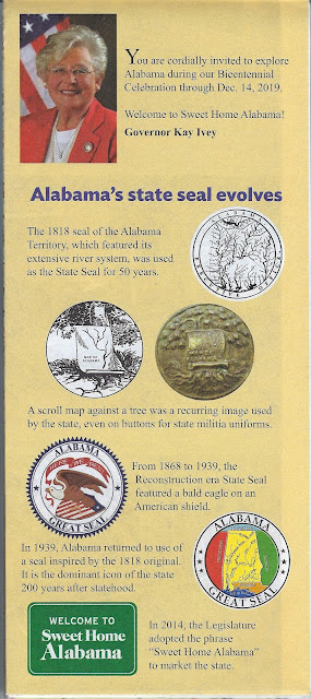


One of the state's most-visited sites finally makes a highway map cover.


And finally three state highway maps from Rand McNally. I could not find a date on this one, but it's probably from the 1970's.


No date on map; Amazon listing has 1984


1997