Showing posts sorted by date for query shelbyville. Sort by relevance Show all posts

Monday, June 4, 2018

Pelham As We Knew It in 1985

We moved to our first house in Pelham in 1985, and as you might expect I've written several postings on this blog related to the city or Shelby County. Historian Bobby Joe Seales and his wife Diane are currently working on Pelham Memories: A Pictorial History that will be available in November 2018. This forthcoming book made me think about the ways Pelham has changed since we moved here and what relics of that time are still around. So I made the rounds one day and photographed some places that were here in 1985 and how they look today.

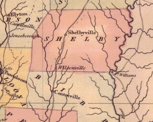
Pelham is actually very old as towns in Alabama go. The town was established as the first seat of Shelby County in 1818 by the Alabama Territorial legislature. In 1826 county government was moved to Columbiana. Originally known as Shelbyville, the place changed its name to Pelham to honor John Pelham sometime in the 1870's. The population remained small for many decades even though the community was located on US Highway 31 and incorporated in 1964. By 1970 just 931 people lived in Pelham.

During that decade the suburbs of northern Shelby County began to boom, and in 1980 Pelham reached a population of 6759. In 1990 it was 9765. The 2016 estimate was 23,050 people. So when we moved here in 1985 there were probably around 8000.

Despite its long history, Pelham has few buildings that are very old. The Fungo Hollow area along Shelby County 35 has some older houses and other such residences are scattered around the city. Very few commercial buildings predate the 1970's, however.

More comments are below the photos.


This goal post in the trees is very close to the house we moved to in 1995 and currently occupy. Someone told Dianne not long after we arrived in the neighborhood that the owners of this property once had a son who was a kicker on the Pelham High School football team


A Food World operated here from January 1974 until a few years ago. Son Amos worked there for a while in high school. That Food World, once part of the Bruno's chain, was owned by Southern Family Markets when it closed in November 2010. 


When we first moved to Pelham the town had few restaurants. None of the many eating places now at the I-65 and Alabama 119 interchange and elsewhere were available then. Sometime in the late 1980's China One opened in the Food World Plaza. We ate there many times when the kids were young. The restaurant has been known as China Cafe for some time; we haven't eaten there in years. Tao long ago became our go-to Asian place in Pelham. 


A Winn-Dixie was located here on U.S. 31 when we moved to Pelham in 1985. This commercial strip, which also houses Cozumel restaurant, is very close to where we used to live. The store closed a few years later, but one reappeared in another place in town as noted below.


Now an Italian restaurant, this building housed a Shoney's when we moved to Pelham. At that time one of the few restaurants in town, the Shoney's moved near the I-65 and Alabama 119 interchange when it began to develop. That location eventually closed; the building was demolished sometime before 2010, and a Burger King is located there now. The Shoney's sign on I-65 did not come down until late 2013. 

We used to really enjoy the breakfast buffets at Shoney's. 


When this commercial strip on U.S. 31 was built, Winn-Dixie was the anchor store where Gold's Gym is now. The grocery store closed a few years ago. 


This building on U.S. 31 near the IHOP has been Riverchase Carpet and Flooring since 1995. Yet it began life in the early 1950's as a Pan American Oil Company gas station. That arrangement didn't last long; although founded in 1916, Pan American had merged with Standard Oil in 1954 and became part of the Amoco brand.

The station was owned by the Acton family for many years. Built soon after U.S. 31 was widened to four lanes, the place offered a stop for travelers heading south from Birmingham. As seen in the photo below, the station had two service bays. The section on the left was a restaurant; the office was on the right.

At some point the station closed and an RV business operated there for a while. I seem to remember that place. When Clyde Pearce bought the building in 1995, it was dilapidated and part of the roof had caved in. Now it's a showplace, and I presume the oldest commercial building in Pelham.


Source: Shelby County Reporter 22 June 2011


This building On U.S. 31 was a bank when we first moved to Pelham, but I don't remember which one. 


This building sure looks like a former Waffle House or Omelette Shop. 


Until recently this building was Valley Elementary School. Our children Amos and Becca both went here and then on to Riverchase Middle School and Pelham High School. The Pelham school system has removed its identity, but the building remains. VES opened in 1964 and lasted until about 2016 with some expansion along the way.


This residence is known as the Lee home and sits on Lee Street near Donut Joe's and just across from the railroad tracks. Built in 1895, the house is one of the oldest structures left in Pelham. The photo above is taken from the Pelham City News, October/November 2010, page 5. That article gives more history of the house. At one time the tiny Pelham Depot was located across the street, but had no bathroom facilities. Passengers waiting for a train would instead come to the Lee home.


Pelham United Methodist Church originated on this spot at the corner of US31 and Shelby County 52. On November 19, 1898, the first sermon by Rev. Felix A. Vann was heard at the New Methodist Episcopal Church South. The church was the first to be located in the city. The sanctuary building was constructed in the 1940's. The Doc Martin Family Life Center behind it opened in 1988.

In October 2006 the church moved to new property on Shelby County 11. An auction of this site was held in April 2007. The sanctuary has been demolished and the photo below shows what remains today on the 4.5 acre site.


This Boggs Pottery business was located on US 31 across from the current Wal-Mart but closed a few years ago. The Boggs family began its pottery business in Prattville in the 1890's and continues today. They were among a number of folk potters active in the state well into the 20th century. The article "Boggs Pottery Shop Has Long History" by state folklorist Joey Brackner can be found in Alabama Folklife 5(1): 6-7, spring 1998.


This structure across US 31 from the old public library and City Hall probably originated as a residence in the 1950's or a bit later. The city has several such buildings from the 1960's and 1970's that have later been put to commercial use at one time or another. The city also has a number of houses in the Fungo Hollow area around Shelby County 35 and 72 that date from those decades. 


This location of the library closed on April 23 so that its contents could be moved to the new library at the city park. When we moved to Pelham the police department was located here; the library was on the first floor with the entrance around back.


A K-Mart was located here in 1985.


Pelham's original WalMart on US31 in the southern part of town is now the home of MasTec Network Solutions


Some other businesses in Pelham that I remember include Fran's Restaurant on U.S. 31. Oddly, even though the place opened in 1961 and operated until September 2013, we never ate there. The place was a popular spot, though. Owner Fran Driver passed away in February 2012. After Fran's closed, a couple of other eateries tried the location. The small commercial strip once housing Fran's was demolished earlier this year. The article "Remembering Fran Driver" can be found in the Pelham City News April 2012, page 7.

Another business was the Command Post, an Army surplus store owned by Jennifer and Nick Bondi who were from Rhodesia, now Zimbabwe. Son Amos and I visited a couple of times when it was located behind Anthony's car wash. The store had opened in a first location in 1984, moved in 1996 and operated there until 2011. 

I also remember several visits with Dianne to the Gift Bag, a boutique with clothes, jewelry, purses and such. I remember the place on Belcher Drive vividly because it was small and so packed there was barely room to move around in it. Sarah Higginbotham opened the Gift Bag in March 1978 and operated it until November 2007. For more about the shop, see Jeremy Gray's article, "Failing Health Causes Boutique Owner to Close Shop after 29 Years" in the Birmingham News 7 November 2007. 


Tuesday, May 15, 2018

Updating Pelham's Historical Marker

In conjunction with Alabama Bicentennial activities, new historical markers are going up all over the state. One was recently placed in Pelham in front of the City Hall building on U.S. 31. 

The new marker actually replaced an older one, which can also be seen below. I've written a blog post about the older marker

Over the life of this blog I've written a number of posts about Pelham; you can find a list here.

A few further comments are below. 


The name was changed from Shelbyville to Pelham sometime after the Civil War ended, although exactly when and by whom are not known. John Pelham was born in Jacksonville, Alabama, and is buried there. 


However, the name Pelham appears on an 1876 map of the state and in an 1880 city of Birmingham directory.

Current state highway maps distributed at welcome centers and rest stops along the Interstates include a community named Pelham in the northeastern corner of Choctaw County. I have been unable so far to locate any information about this place. Google Earth doesn't show much there but houses, trees and roads; perhaps I'll drive down one day and check it out.


Here's the original marker, which had the same text on both sides. The date of installation in the lower right is hard to read but appears to be 1976. 


Tuesday, April 3, 2018

Pondering Alabama Maps (8): Shelby County in 1822 and 1825

I've written in a previous blog post "Once Shelbyville, A.T., Now Pelham" about the city's early history as the Shelby County seat. That lasted from 1817 in the Alabama Territory period until 1826, when Columbiana became the county seat. Pelham changed its name to honor Major John Pelham sometime in the 1870's.

Below the photo of the historical marker describing all this you'll find two maps of the county from 1822 and 1825. These snapshots were taken from two maps of Alabama created when the area was still in its first decade after becaming a territory and then a state. Despite this early era, the population of the county was more than 2400 in 1820 and over 5700 by 1830.

The 1822 state map was created by Fielding Lucas, Jr.[1781-1854], a successful cartographer and map publisher in Baltimore in the early 19th century. Lucas was the primary engraver on A Complete Historical, Chronological and Geographical American Atlas published by the firm of Carey & Lea in Philadelphia in 1822. This atlas was the most detailed and important one of the United States at the time of publication. A copy of that first edition is currently for sale at $14, 000, which gives some idea of its importance in the mapping history of the United States. The atlas also included extensive historical background on states, cities, etc. 

The 1825 version of Shelby County's map appeared in a German edition of the Carey and Lea atlas. The work was completely re-engraved under military and commercial cartographer Carl Ferdinand Weiland [1782-1847]. The Shelby County map is a very good copy of Lucas' but slight differences can be found. Compare the western borders of the county on each map, for instance. 

Some other blog posts about Pelham on other historical maps can be found here. You can read more about the only other county town on these maps, Wilsonville, here


This 1822 view of Shelby County is taken from a state map by Fielding Lucas, Jr., and published by Carey and Lea of Philadelphia.

Source: Historical Maps of Alabama


This view of Shelby County appeared in the 1825 German edition of Carey & Lea's atlas.


Tuesday, September 26, 2017

What Happened to Old Tuskaloosa Road?

Here's another bit of history I've passed many times over the years but only recently noticed--this street sign in Pelham announcing Old Tuskaloosa Road. That's a mighty new looking sign for such a short road, so I'm not sure what the story is behind that. You can see where it goes below.

In the Heritage of Shelby County, Alabama [1999, p.14], a section on early transportation notes the following:

"State of Alabama, Act, May 24, 1828, Vol. 4, p. 232, Road from Shelbyville to Tuskaloosa."

This reference apparently cites an Act of Congress authorizing the road--and perhaps funding--but so far I have been unable to track it down. Shelbyville is better known as Pelham today, and was the county seat until 1826 when Coumbiana was chosen. Tuscaloosa served as state capitol from 1826 until 1846, so roads to it were no doubt important. 

In the U.S. Statutes at Large, Volume 4, 1824-1835, p. 225, I did find this entry in a list of "post-roads" authorized by Congress on March 2, 1827: "From Moulton, by Walker Courthouse, to Tuscaloosa." I did not find any mention of the Shelbyville to Tuscaloosa road on page 232. Several roads in Alabama were authorized on May 24, 1828, but not that one. 

So where is the rest of this mysterious Old Tuscaloosa Road? How long did it last as an intact road over that distance? 

A Google search turns up such a designation in Helena, but also Jasper and a couple of other places. You can see existing roads in the area in the 1833 map below.

Further investigation awaits. 


Block USA is a construction company. Old Tuskaloosa Road ends quickly at their complex. Across Lee Street is the back of one of the buildings in the Summer Classics site that faces US 31. 


Here's a satellite view from Google Earth taken November 3, 2016.


This 1833 excerpt from a state map by Henry Tanner shows the existing roads. 

Source: Historical Maps of Alabama 


Tuesday, September 19, 2017

Montevallo is Missing! [My 350th blog post!]

Well, sort of. And only on a map. Sort of....let's investigate.

On September 9th, the city of Montevallo had a festival to celebrate it's bicentennial. Like Pelham, once known as Shelbyville and Shelby County's original seat of government, Montevallo predates Alabama statehood in 1819. 

The first white settler in the county, Jess Wilson, arrived in 1814 and others followed as the Indian threat diminshed. The area became "Wilson's Hill" by 1822 and Montevallo in 1826 according to Clark Hultquist and Carey Heatherly's Montevallo [Arcadia Images of America series, 2011, p. 11]. You can read some more early history here. Montevallo was incorporated by the state legislature in 1848 when almost 1000 people lived there. 

Columbia in the southern part of the county became the seat in 1826 and a post office was established. The town became Columbiana in 1832 and incorporated in 1837.

I was perusing some old Alabama maps recently and noticed something interesting related to this early history. Excerpts are below; all map portions are taken from the state maps at the University of Alabama's Historical Map Archive. You'll note some mysteries as you look at these maps and read my comments. Montevallo appears on a map as early as 1823, then an 1824 map lists "Wilson Hill" but no "Montevallo". 

These maps from the 1820's and 1830's vary in the towns shown. Making maps in those days was hardly a standardized business. Did mapmakers in Philadelphia or Baltimore actually visit these places or copy from previous maps or what?

Feel free to leave insights in the comments section!


On John Melish's 1818 map of Alabama, we see Shelby County in its earliest form. The county was created by the legislature of the Alabama Territory in February 1818. The only named locations in Shelby at this time were Fort Strother and Fort Villanos, Camp Wills and Camp Bradley and Littafuchee. All but Fort Villanos would become part of St. Clair County when it was created in November.

Fort Strother was constructed during the Creek War by several thousand of Andrew Jackson's Tennessee Militia  just before the Battle of Talladega on November 8, 1813. Presumably the other fort and camps were also a part of that war. Littafuchee was an Upper Creek town; the name means "making of arrows." In October 1813 some of the Militia captured the town 


Portion of Fielding Lucas' 1822 map of Alabama that shows two towns in Shelby County at that time. A post office was established at the current Wilsonville in the same year; the town wasn't incorporated until 1897. But this map shows a weirdly shaped Shelby County; is this Wilsonville supposed to be Wilson's Hill? Montevallo is in southern Shelby County, after all, and today's Wilsonville is in the eastern part near the Coosa River.


On this section of Henry S. Tanner's 1823 state map, we find Shelbyville and Montevallo as well as Kelley's Village in the northeastern corner of the county.


Anthony Finley's 1824 state map lists only Shelbyville and Wilson Hill. What happened to "Montevallo"?


Henry S. Tanner's 1825 map again lists not only Shelbyville and Montevallo, but  also Kelley's Village. That third place is a mystery; it doesn't appear in Virginia Foscue's Place Names in Alabama [University of Alabama Press, 1989]. However, there are a Kelley Mountain and Kelley Creek in Shelby County.


Taken from David Burr's 1836 map of Alabama. Notice there are still only two towns noted in Shelby County, Shelbyville and now Montevallo. Poor Columbiana, the country seat, is getting no recognition here.